3D images show what lies beneath Mars poles

January 4, 2017

Washington, Jan 4: Scientists using data from a NASA probe have unveiled 3D subsurface images of Mars polar ice caps, showing previously obscured layering, larger volume of frozen carbon dioxide and bowl-shaped features that may be buried impact craters.mars
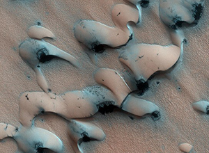
The information will help scientists better understand Martian climate changes and may allow them to determine the age of the polar caps without using climate models.

The 3D data volumes were assembled from observations by the Shallow Radar (SHARAD) onboard NASA's Mars Reconnaissance Orbiter (MRO) during more than 2000 orbit passes over each Martian pole.

"We have applied industry-developed techniques in a very novel fashion to a martian dataset, producing 3D volumes that are each over 600 times larger than any terrestrial or planetary dataset of this kind," said Nathaniel E Putzig, a senior scientist at the Planetary Science Institute in the US.

"It is gratifying to see so plainly in the SHARAD volumes structures that took years of effort to characterise with the single-orbit profiles," Putzig said.

Layering seen at the surface of the martian polar caps has been studied for decades. It has long been thought to represent a record of climate changes on that planet.

The interior structures of the caps remained a mystery until the arrival of radar sounders at Mars in the last decade.

An early version of the north polar 3D volume helped to assess the quantity of water ice transferred to the polar caps in the most recent retreat from a martian ice age.

First looks at the south polar 3D volume indicate that previously mapped deposits of carbon dioxide ice are somewhat larger than reported.

In both polar 3D volumes, known impact craters in and near the polar caps that are partially filled with ice have distinctive bowl-shaped signatures in the radar data, and similar signatures are found elsewhere within the polar ices but without any surface expression.

Whether the latter structures truly are impact craters remains to be determined.
Age estimates of planetary surfaces throughout the solar system rely on statistical data for impact craters on the Moon's surface calibrated to radiometrically dated samples returned during the Apollo programme.

This method has been used to estimate the surface ages of the martian polar caps, but estimates for the ages of the caps themselves have had to rely on numerical models of past climate changes.

If a sufficient number of the bowl-shaped features found in the radar volumes are shown to be impact craters, scientists will be able to assess the age of the polar caps using cratering statistics alone.

The extent to which age estimates from this new volumetric method agree or disagree with those from climate models will have important implications for the accuracy of these dating techniques.

Comments

Add new comment

  • Coastaldigest.com reserves the right to delete or block any comments.
  • Coastaldigset.com is not responsible for its readers’ comments.
  • Comments that are abusive, incendiary or irrelevant are strictly prohibited.
  • Please use a genuine email ID and provide your name to avoid reject.
Agencies
February 5,2020

San Francisco, Feb 5: After a German artist, Simon Weckert, demonstrated how he "hacked" Google Maps with 99 smartphones and a wagon to create "virtual traffic jams" on the streets of Berlin, Google responded to the incident saying it "appreciates" creative use of maps.

Admitting that it has not quite cracked travelling by wagon, the tech giant also hinted that it might use cases like this to improve how its maps work.

"We appreciate seeing creative uses of Google Maps like this as it helps us make maps work better over time," 9to5Google quoted a Google spokesperson as saying.

In a YouTube video, Weckert showed that he put 99 smartphones with Google Maps onto a small wagon cart and then wheeled that cart around various streets in Berlin, including outside the Google office, Android Authority reported on Monday.

The smartphones "apparently fooled Google Maps" into thinking that there was a high concentration of users on those streets.

Because the second-hand phones were in a cart, Maps was further tricked into believing that the traffic was slow-moving.

As a result, the navigation app started showing virtual traffic jams by turning green streets to red in the online navigational tool, showcasing how digital technology can have a real impact on the real world.

"Traffic data in Google Maps is refreshed continuously thanks to information from a variety of sources, including aggregated anonymised data from people who have location services turned on and contributions from the Google Maps community," the Google spokesperson said.

"We've launched the ability to distinguish between cars and motorcycles in several countries including India, Indonesia and Egypt, though we haven't quite cracked travelling by wagon," the statement added. After a German artist, Simon Weckert, demonstrated how he "hacked" Google Maps with 99 smartphones and a wagon to create "virtual traffic jams" on the streets of Berlin, Google responded to the incident saying it "appreciates" creative use of maps.

Admitting that it has not quite cracked travelling by wagon, the tech giant also hinted that it might use cases like this to improve how its maps work.

"We appreciate seeing creative uses of Google Maps like this as it helps us make maps work better over time," 9to5Google quoted a Google spokesperson as saying.

In a YouTube video, Weckert showed that he put 99 smartphones with Google Maps onto a small wagon cart and then wheeled that cart around various streets in Berlin, including outside the Google office, Android Authority reported on Monday.

The smartphones "apparently fooled Google Maps" into thinking that there was a high concentration of users on those streets.

Because the second-hand phones were in a cart, Maps was further tricked into believing that the traffic was slow-moving.

As a result, the navigation app started showing virtual traffic jams by turning green streets to red in the online navigational tool, showcasing how digital technology can have a real impact on the real world.

"Traffic data in Google Maps is refreshed continuously thanks to information from a variety of sources, including aggregated anonymised data from people who have location services turned on and contributions from the Google Maps community," the Google spokesperson said.

"We've launched the ability to distinguish between cars and motorcycles in several countries including India, Indonesia and Egypt, though we haven't quite cracked travelling by wagon," the statement added.

Comments

Add new comment

  • Coastaldigest.com reserves the right to delete or block any comments.
  • Coastaldigset.com is not responsible for its readers’ comments.
  • Comments that are abusive, incendiary or irrelevant are strictly prohibited.
  • Please use a genuine email ID and provide your name to avoid reject.
Agencies
May 19,2020

Cybersecurity researchers on Monday warned of a Trojan malware campaign which is targeting India's co-operative banks using COVID-19 as a bait.

Seqrite, the enterprise arm of IT security firm Quick Heal Technologies, detected the new wave of Adwind Java Remote Access Trojan (RAT) campaign.

Researchers at Seqrite warned that if attackers are successful, they can take over the victim's device to steal sensitive data like SWIFT logins and customer details and move laterally to launch large scale cyberattacks and financial frauds.

According to the researchers, the Java RAT campaign starts with a spear-phishing email which claims to have originated from either the Reserve Bank of India or a nationalised bank.

The content of the email refers to COVID-19 guidelines or a financial transaction, with detailed information in an attachment, which is a zip file containing a JAR based malware.

Upon further investigation, researchers at Seqrite found that the JAR based malware is a Remote Access Trojan that can run on any machine which has Java runtime enabled and hence it can impact a variety of endpoints, irrespective of their base operating system.

Once the RAT is installed, the attacker can take over the victim's device, send commands from a remote machine, and spread laterally in the network.

In addition, this malware can also log keystrokes, capture screenshots, download additional payloads, and extract sensitive user information, Seqrite said, adding that such attack campaigns can effectively jeopardise the privacy and security of sensitive data at the co-operative banks and result in large scale attacks and financial frauds.

To prevent such attacks, users need to exercise ample caution and avoid opening attachments and clicking on web links in unsolicited emails.

Banks should also keep their operating systems updated and have a full-fledged security solution installed on all the devices, Seqrite advised.

Comments

Add new comment

  • Coastaldigest.com reserves the right to delete or block any comments.
  • Coastaldigset.com is not responsible for its readers’ comments.
  • Comments that are abusive, incendiary or irrelevant are strictly prohibited.
  • Please use a genuine email ID and provide your name to avoid reject.
Agencies
February 17,2020

Google on Monday announced it is gradually winding down its free public Wi-Fi Station programme currently available at over 400 railway stations in India, and will work with the Indian Railways and Railtel Corporation to help them with existing sites so they can remain useful resources for people.

Google launched its Station initiative in India in 2015 to bring fast, free public Wi-Fi to over 400 of the busiest railway stations in the country by mid-2020.

"We crossed that number by June 2018 and implemented Station in thousands of other locations around the country in partnership with telecommunications companies, ISPs and local authorities," Caesar Sengupta, Vice President, Payments and Next Billion Users, Google, said in a statement.

"Over time, partners in other countries asked for Station too and we responded accordingly. We're grateful for these partnerships, especially with the Indian Railways and the Government of India, that helped us serve millions of users over the last few years," he added.

According to Google, the decision to shut Station has been taken keeping the affordable mobile data plans and mobile connectivity in mind that is improving globally including in India.

"India, specifically now has among the cheapest mobile data per GB in the world, with mobile data prices having reduced by 95 per cent in the last 5 years, as per TRAI in 2019," said Sengupta.

The Indian users consume close to 10GB of data, each month, on average, according to reports.

"Our commitment to supporting the next billion users remains stronger than ever, from continuing our efforts to make the internet work for more people and building more relevant and helpful apps and services," Sengupta noted.

Global networking giant Cisco last year teamed up with Google to roll out free, high-speed public Wi-Fi access globally, starting with India.

The first pilot under the partnership was rolled out at 35 locations in Bengaluru.

Sengupta said that in addition to the changed context, the challenge of varying technical requirements and infrastructure among our partners across countries has also made it difficult for Station to scale and be sustainable, especially for our partners.

"And when we evaluate where we can truly make an impact in the future, we see greater need and bigger opportunities in building products and features tailored to work better for the next billion user markets," he said.

Comments

Add new comment

  • Coastaldigest.com reserves the right to delete or block any comments.
  • Coastaldigset.com is not responsible for its readers’ comments.
  • Comments that are abusive, incendiary or irrelevant are strictly prohibited.
  • Please use a genuine email ID and provide your name to avoid reject.