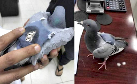
Pigeon caught smuggling drugs in Kuwait

May 24, 2017

Kuwait, May 24: There was a time when pigeons were used to deliver messages across countries in the absence of faster means of communication.

pigeon

But in the contemporary times, the same bird is being used for criminal purposes. In Kuwait, a homing pigeon was caught transporting drugs by custom officials.

Around 178 pills were found wrapped around the bird that reportedly came from Iraq and was being tracked by the customs department.

According to Al Arabiya, the pigeon was caught by the officials above a building near their office.

It has not been mentioned as to what kind of pills were transported.

Comments

Add new comment

  • Coastaldigest.com reserves the right to delete or block any comments.
  • Coastaldigset.com is not responsible for its readers’ comments.
  • Comments that are abusive, incendiary or irrelevant are strictly prohibited.
  • Please use a genuine email ID and provide your name to avoid reject.
Agencies
February 5,2020

San Francisco, Feb 5: After a German artist, Simon Weckert, demonstrated how he "hacked" Google Maps with 99 smartphones and a wagon to create "virtual traffic jams" on the streets of Berlin, Google responded to the incident saying it "appreciates" creative use of maps.

Admitting that it has not quite cracked travelling by wagon, the tech giant also hinted that it might use cases like this to improve how its maps work.

"We appreciate seeing creative uses of Google Maps like this as it helps us make maps work better over time," 9to5Google quoted a Google spokesperson as saying.

In a YouTube video, Weckert showed that he put 99 smartphones with Google Maps onto a small wagon cart and then wheeled that cart around various streets in Berlin, including outside the Google office, Android Authority reported on Monday.

The smartphones "apparently fooled Google Maps" into thinking that there was a high concentration of users on those streets.

Because the second-hand phones were in a cart, Maps was further tricked into believing that the traffic was slow-moving.

As a result, the navigation app started showing virtual traffic jams by turning green streets to red in the online navigational tool, showcasing how digital technology can have a real impact on the real world.

"Traffic data in Google Maps is refreshed continuously thanks to information from a variety of sources, including aggregated anonymised data from people who have location services turned on and contributions from the Google Maps community," the Google spokesperson said.

"We've launched the ability to distinguish between cars and motorcycles in several countries including India, Indonesia and Egypt, though we haven't quite cracked travelling by wagon," the statement added. After a German artist, Simon Weckert, demonstrated how he "hacked" Google Maps with 99 smartphones and a wagon to create "virtual traffic jams" on the streets of Berlin, Google responded to the incident saying it "appreciates" creative use of maps.

Admitting that it has not quite cracked travelling by wagon, the tech giant also hinted that it might use cases like this to improve how its maps work.

"We appreciate seeing creative uses of Google Maps like this as it helps us make maps work better over time," 9to5Google quoted a Google spokesperson as saying.

In a YouTube video, Weckert showed that he put 99 smartphones with Google Maps onto a small wagon cart and then wheeled that cart around various streets in Berlin, including outside the Google office, Android Authority reported on Monday.

The smartphones "apparently fooled Google Maps" into thinking that there was a high concentration of users on those streets.

Because the second-hand phones were in a cart, Maps was further tricked into believing that the traffic was slow-moving.

As a result, the navigation app started showing virtual traffic jams by turning green streets to red in the online navigational tool, showcasing how digital technology can have a real impact on the real world.

"Traffic data in Google Maps is refreshed continuously thanks to information from a variety of sources, including aggregated anonymised data from people who have location services turned on and contributions from the Google Maps community," the Google spokesperson said.

"We've launched the ability to distinguish between cars and motorcycles in several countries including India, Indonesia and Egypt, though we haven't quite cracked travelling by wagon," the statement added.

Comments

Add new comment

  • Coastaldigest.com reserves the right to delete or block any comments.
  • Coastaldigset.com is not responsible for its readers’ comments.
  • Comments that are abusive, incendiary or irrelevant are strictly prohibited.
  • Please use a genuine email ID and provide your name to avoid reject.
Agencies
June 19,2020

Denser places, assumed by many to be more conducive to the spread of the coronavirus that causes COVID-19, are not linked to higher infection rates, say researchers.

The study, led by Johns Hopkins University, published in the Journal of the American Planning Association, also found that dense areas were associated with lower COVID-19 death rates.

"These findings suggest that urban planners should continue to practice and advocate for compact places rather than sprawling ones, due to the myriad well-established benefits of the former, including health benefits," says study lead author Shima Hamidi from Johns Hopkins Bloomberg School of Public Health in the US.

For their analysis, the researchers examined SARS-CoV-2 infection rates and COVID-19 death rates in 913 metropolitan counties in the US.

When other factors such as race and education were taken into account, the authors found that county density was not significantly associated with county infection rate.

The findings also showed that denser counties, as compared to more sprawling ones, tended to have lower death rates--possibly because they enjoyed a higher level of development including better health care systems.

On the other hand, the research found that higher coronavirus infection and COVID-19 mortality rates in counties are more related to the larger context of metropolitan size in which counties are located.

Large metropolitan areas with a higher number of counties tightly linked together through economic, social, and commuting relationships are the most vulnerable to the pandemic outbreaks.

According to the researchers, recent polls suggest that many US citizens now consider an exodus from big cities likely, possibly due to the belief that more density equals more infection risk.

Some government officials have posited that urban density is linked to the transmissibility of the virus.

"The fact that density is unrelated to confirmed virus infection rates and inversely related to confirmed COVID-19 death rates is important, unexpected, and profound," said Hamidi.

"It counters a narrative that, absent data and analysis, would challenge the foundation of modern cities and could lead to a population shift from urban centres to suburban and exurban areas," Hamidi added.

The analysis found that after controlling for factors such as metropolitan size, education, race, and age, doubling the activity density was associated with an 11.3 per cent lower death rate.

The authors said that this is possibly due to faster and more widespread adoption of social distancing practices and better quality of health care in areas of denser population.

The researchers concluded that a higher county population, a higher proportion of people age 60 and up, a lower proportion of college-educated people, and a higher proportion of African Americans were all associated with a greater infection rate and mortality rate.

Comments

Add new comment

  • Coastaldigest.com reserves the right to delete or block any comments.
  • Coastaldigset.com is not responsible for its readers’ comments.
  • Comments that are abusive, incendiary or irrelevant are strictly prohibited.
  • Please use a genuine email ID and provide your name to avoid reject.
Agencies
May 15,2020

Kolkata, May 15: Veteran Bengali author Debesh Roy, who was conferred the Sahitya Akademi award for his novel 'Teesta Parer Brittanto', died at a private hospital in Kolkata on Thursday, his family members said.

Roy was 84 and he is survived by his son. His wife had died earlier.

He was admitted to the hospital near his residence at Baguihati, in the eastern fringes of the city, on Wednesday after having symptoms like sodium potasium imbalance, sugar problem and breathing problem, his family members said.

He suffered a massive cardiac arrest and died at 10.50 PM.

A regular contributor to a number of Bengali dailies, he was a staunch critic of the attacks on liberals by in the country in recent times and attended protest meetings despite his failing health.

He was born in Pabna in present-day Bangladesh on December 17, 1936. He had five decades of career as a writer.

Besides Teesta Parer Britanta', he will be remembered for books like Borisaler Jogen Mondal , Manush Khun Kore Keno and Samay Asamayer Brittanto . His first book was Jajati.

His last rites will be performed tomorrow.

Comments

Add new comment

  • Coastaldigest.com reserves the right to delete or block any comments.
  • Coastaldigset.com is not responsible for its readers’ comments.
  • Comments that are abusive, incendiary or irrelevant are strictly prohibited.
  • Please use a genuine email ID and provide your name to avoid reject.