Experts question safety features of China's straddling bus

August 8, 2016

Beijing, Aug 8: China's "straddling bus", trumpeted as an innovative idea to deal with traffic jams, is facing increasing scrutiny with many questioning the vehicle's safety features and whether it would ever come into service, a media report said today.

straddlingbus1

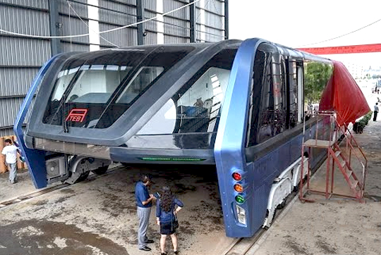
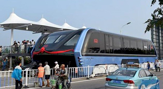
The Transit Elevated Bus (TEB), grabbed worldwide attention last week after China's official published pictures of the vehicle during a test run on a 300-metre track in Qinhuangdao city in Hebei province.

The bus is designed to run on rails and rises two metres above the road, allowing cars to pass underneath to ease congestion.

While the state-run Xinhua suggested last week the project was an excuse to raise funds rather than create an innovative solution to traffic problem, the experts have also questioned the safety and practicality of the technology, Hong-Kong based South China Morning Post reported.

It would be difficult for the bus to negotiate turns and motorists driving under it would have their line of sight severely limited, increasing the chance of accidents on the road, said Sun Zhang, a transportation professor at Tongji University in Shanghai and an expert in urban track transport systems.

"It can only run on wide and straight roads. In big cities where roads are winding and jammed [with traffic], such roads are in shortly supply. The biggest advantage of this project is that its designers have rich imaginations," he said.

straddlingbus2

Several employees of the TEB at Qinhuangdao city draped the bus with black curtains to prevent bystanders looking at the vehicle as the project has kindled the interest of curious local residents, the report said.

Also the idea of a bus to ease road congestion is attractive in China where car ownership is rapidly increasing, along with the number of traffic jams.

China had 172 million cars on the road at the end of last year, with 280 million licensed drivers. Research by the car-hailing service Didi Chuxing, based on data gathered in 400 Chinese cities, said the average car speed was less than 25 kmph in the first half of this year, the report said.

The publicity has created a wave of interests specially among the investors. After a series of media reports in China have questioned the technological viability and the feasibility of the project, some investors worried about the scheme to come down to check out the site.

"The company and the project are beset by so many questions. We are all worried," Zhang Ying, an investor, said

He has invested about 500,000 yuan (USD 75085) into Huaying after its sales staff told him annual returns could be as high as 14 per cent, the report said.

Yao Xu, an official in charge of press inquiries at TEB Technology told 'Morning Post' that an "official test run" would be arranged in the coming weeks.

Comments

Add new comment

  • Coastaldigest.com reserves the right to delete or block any comments.
  • Coastaldigset.com is not responsible for its readers’ comments.
  • Comments that are abusive, incendiary or irrelevant are strictly prohibited.
  • Please use a genuine email ID and provide your name to avoid reject.
Agencies
February 17,2020

Google on Monday announced it is gradually winding down its free public Wi-Fi Station programme currently available at over 400 railway stations in India, and will work with the Indian Railways and Railtel Corporation to help them with existing sites so they can remain useful resources for people.

Google launched its Station initiative in India in 2015 to bring fast, free public Wi-Fi to over 400 of the busiest railway stations in the country by mid-2020.

"We crossed that number by June 2018 and implemented Station in thousands of other locations around the country in partnership with telecommunications companies, ISPs and local authorities," Caesar Sengupta, Vice President, Payments and Next Billion Users, Google, said in a statement.

"Over time, partners in other countries asked for Station too and we responded accordingly. We're grateful for these partnerships, especially with the Indian Railways and the Government of India, that helped us serve millions of users over the last few years," he added.

According to Google, the decision to shut Station has been taken keeping the affordable mobile data plans and mobile connectivity in mind that is improving globally including in India.

"India, specifically now has among the cheapest mobile data per GB in the world, with mobile data prices having reduced by 95 per cent in the last 5 years, as per TRAI in 2019," said Sengupta.

The Indian users consume close to 10GB of data, each month, on average, according to reports.

"Our commitment to supporting the next billion users remains stronger than ever, from continuing our efforts to make the internet work for more people and building more relevant and helpful apps and services," Sengupta noted.

Global networking giant Cisco last year teamed up with Google to roll out free, high-speed public Wi-Fi access globally, starting with India.

The first pilot under the partnership was rolled out at 35 locations in Bengaluru.

Sengupta said that in addition to the changed context, the challenge of varying technical requirements and infrastructure among our partners across countries has also made it difficult for Station to scale and be sustainable, especially for our partners.

"And when we evaluate where we can truly make an impact in the future, we see greater need and bigger opportunities in building products and features tailored to work better for the next billion user markets," he said.

Comments

Add new comment

  • Coastaldigest.com reserves the right to delete or block any comments.
  • Coastaldigset.com is not responsible for its readers’ comments.
  • Comments that are abusive, incendiary or irrelevant are strictly prohibited.
  • Please use a genuine email ID and provide your name to avoid reject.
Agencies
July 4,2020

The Mars Colour Camera (MCC) onboard ISRO's Mars Orbiter Mission has captured the image of Phobos, the closest and biggest moon of Mars.

The image was taken on July 1 when MOM was about 7,200 km from Mars and 4,200 km from Phobos.

"Spatial resolution of the image is 210 m.

This is a composite image generated from 6 MCC frames and has been color corrected," ISRO said in an update along with the image.

Phobos is largely believed to be made up of carbonaceous chondrites.

According to ISRO, "the violent phase that Phobos has encountered is seen in the large section gouged out from a past collision (Stickney crater) and bouncing ejecta."

"Stickney, the largest crater on Phobos along with the other craters (Shklovsky, Roche & Grildrig) are also seen in this image," it said.

The mission also known as Mangalyaan was initially meant to last six months, but subsequently ISRO had said it had enough fuel for it to last "many years."

The country had on September 24, 2014 successfully placed the Mars Orbiter Mission spacecraft in orbit around the red planet, in its very first attempt, thus breaking into an elite club.

ISRO had launched the spacecraft on its nine-month- long odyssey on a homegrown PSLV rocket from Sriharikota in Andhra Pradesh on November 5, 2013.

It had escaped the earth's gravitational field on December 1, 2013.

The Rs 450-crore MOM mission aims at studying the Martian surface and mineral composition as well as scan its atmosphere for methane (an indicator of life on Mars).

The Mars Orbiter has five scientific instruments - Lyman Alpha Photometer (LAP), Methane Sensor for Mars (MSM), Mars Exospheric Neutral Composition Analyser (MENCA), Mars Colour Camera (MCC) and Thermal Infrared Imaging Spectrometer

Comments

Add new comment

  • Coastaldigest.com reserves the right to delete or block any comments.
  • Coastaldigset.com is not responsible for its readers’ comments.
  • Comments that are abusive, incendiary or irrelevant are strictly prohibited.
  • Please use a genuine email ID and provide your name to avoid reject.
Agencies
February 5,2020

San Francisco, Feb 5: After a German artist, Simon Weckert, demonstrated how he "hacked" Google Maps with 99 smartphones and a wagon to create "virtual traffic jams" on the streets of Berlin, Google responded to the incident saying it "appreciates" creative use of maps.

Admitting that it has not quite cracked travelling by wagon, the tech giant also hinted that it might use cases like this to improve how its maps work.

"We appreciate seeing creative uses of Google Maps like this as it helps us make maps work better over time," 9to5Google quoted a Google spokesperson as saying.

In a YouTube video, Weckert showed that he put 99 smartphones with Google Maps onto a small wagon cart and then wheeled that cart around various streets in Berlin, including outside the Google office, Android Authority reported on Monday.

The smartphones "apparently fooled Google Maps" into thinking that there was a high concentration of users on those streets.

Because the second-hand phones were in a cart, Maps was further tricked into believing that the traffic was slow-moving.

As a result, the navigation app started showing virtual traffic jams by turning green streets to red in the online navigational tool, showcasing how digital technology can have a real impact on the real world.

"Traffic data in Google Maps is refreshed continuously thanks to information from a variety of sources, including aggregated anonymised data from people who have location services turned on and contributions from the Google Maps community," the Google spokesperson said.

"We've launched the ability to distinguish between cars and motorcycles in several countries including India, Indonesia and Egypt, though we haven't quite cracked travelling by wagon," the statement added. After a German artist, Simon Weckert, demonstrated how he "hacked" Google Maps with 99 smartphones and a wagon to create "virtual traffic jams" on the streets of Berlin, Google responded to the incident saying it "appreciates" creative use of maps.

Admitting that it has not quite cracked travelling by wagon, the tech giant also hinted that it might use cases like this to improve how its maps work.

"We appreciate seeing creative uses of Google Maps like this as it helps us make maps work better over time," 9to5Google quoted a Google spokesperson as saying.

In a YouTube video, Weckert showed that he put 99 smartphones with Google Maps onto a small wagon cart and then wheeled that cart around various streets in Berlin, including outside the Google office, Android Authority reported on Monday.

The smartphones "apparently fooled Google Maps" into thinking that there was a high concentration of users on those streets.

Because the second-hand phones were in a cart, Maps was further tricked into believing that the traffic was slow-moving.

As a result, the navigation app started showing virtual traffic jams by turning green streets to red in the online navigational tool, showcasing how digital technology can have a real impact on the real world.

"Traffic data in Google Maps is refreshed continuously thanks to information from a variety of sources, including aggregated anonymised data from people who have location services turned on and contributions from the Google Maps community," the Google spokesperson said.

"We've launched the ability to distinguish between cars and motorcycles in several countries including India, Indonesia and Egypt, though we haven't quite cracked travelling by wagon," the statement added.

Comments

Add new comment

  • Coastaldigest.com reserves the right to delete or block any comments.
  • Coastaldigset.com is not responsible for its readers’ comments.
  • Comments that are abusive, incendiary or irrelevant are strictly prohibited.
  • Please use a genuine email ID and provide your name to avoid reject.