Heavy rains lashing Andhra as cyclone nears coast

November 22, 2013

Hyderabad, Nov 22: Helen, the cyclonic storm in Bay of Bengal, is heading to hit Andhra Pradesh coast later in the day while several parts of the region started receiving heavy rains under its impact.rain_copy

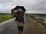
An alert has been sounded in the coastal districts, while authorities are taking precautionary measures including evacuation of people from low-lying area to minimize the damage from the cyclone in the Bay of Bengal.

According to the Indian Meteorological Department (IMD), the severe cyclonic storm will cross the coast near Machillipatnam around Friday afternoon.

IMD has issued cyclone warning to Andhra Pradesh coast.

The IMD's bulletin early Friday said 'Helen' over west central Bay of Bengal moved slightly west-northwestwards and lay centred at about 120 km east of Machillipatnam, 250 km east-northeast of Ongole and 200 km south-southwest of Vishakhapatnam.

It would move west-northwestwards for some time, then westward and cross Andhra Pradesh coast near Machillipatnam.

Heavy rains accompanied by strong gales are lashing Krishna, Visakhapatnam, West Godavari and some other parts of the coastal region since early Friday. Authorities have declared holiday for educational institutions.

Under the influence of cyclone, rainfall at most places with heavy to very heavy rainfall at a few places would occur over north coastal Andhra Pradesh and adjoining Guntur, Krishna, West Godavari districts of south coastal Andhra Pradesh during next 48 hours. Isolated extremely heavy falls (25cm or more) are also likely.

Rainfall at most places with isolated heavy to very heavy falls would occur over remaining districts of south coastal Andhra Pradesh Rayalseema and Telangana Friday and Saturday.

Squally winds speed reaching 55-65 kmph gusting to 75 kmph would prevail along and off south Andhra coast. The wind speed would gradually increase up to gale wind speed of 100-110 kmph, gusting to 120 kmph at the time of landfall.

The IMD has warned that storm surge of about 1 to 1.5m height would inundate the low lying areas of west and east Godavari Krishna, Guntur and adjoining areas of Prakasham district at the time of landfall.

Sea condition will be rough to very rough along and off south Andhra coast. Extensive damage to thatched roofs and huts and minor damage to power and communication lines was expected due to uprooting of trees.

Fishermen have been advised not to venture into the sea. The authorities have hoisted warning signals at all ports along Andhra coast.

Chief Minister N. Kiran Kumar Reddy, who reviewed the situation in coastal districts with top officials at a meeting in Hyderabad Thursday, directed the chief secretary to closely monitor the situation with all collectors of coastal districts to face any eventuality.

A control room to monitor the situation has been opened at the state secretariat in Hyderabad. The control room numbers are 040-23456005, 23451043.

Krishna district collector Raghunandan Rao said a holiday was declared for all educational institution in coastal areas.

He said 10 relief camps were opened for people evacuated from low-lying areas. Sixty personnel of National Disaster Response Force ( NDRF) personnel were deployed for rescue and relief operations.

A control room in Krishna district collector's office was opened. Its telephone numbers are 08672-252572  08672-251077.

Helen is threatening Andhra coast even as the state is yet to recover from the massive damages caused by 'Phailin' and heavy rains in October.

Andhra Pradesh has nearly 1,000 km long coastline and the nine district faces cyclone threats every year, especially between September and November.

Comments

Add new comment

  • Coastaldigest.com reserves the right to delete or block any comments.
  • Coastaldigset.com is not responsible for its readers’ comments.
  • Comments that are abusive, incendiary or irrelevant are strictly prohibited.
  • Please use a genuine email ID and provide your name to avoid reject.
News Network
January 17,2020

Jan 17: India's "high power" communication satellite GSAT-30 was successfully launched in the early hours of January 17, the Indian Space Research Organisation (ISRO) said.

The satellite, aimed at providing high-quality television, telecommunications and broadcasting services, was launched onboard Ariane 5 rocket from French Guiana.

Blasting off from the Ariane Launch Complex in Kourou, a French territory located in northeastern coast of South America at 2.35 am IST, European space consortium Arianespace's Ariane 5 vehicle injected GSAT-30 into the orbit in a flawless flight lasting about 38 minutes.

Arianespace CEO Stéphane Israël tweeted about the successful launch of GSAT-30.

ISRO's U R Rao Satellite Centre Director P Kunhikrishnan, who was present in Kourou, congratulated the ISRO community and Arianespace team on the successful launch.

Calling it an "excellent start" to 2020 for ISRO with the launch, he said, "The mission team at the master control facility have already acquired the satellite and they will immediately complete the post launch operations...."

The 3,357-kg satellite, which was deployed from the lower passenger position of Ariane-5 launch vehicle (VA 251) into to geostationary transfer orbit (GTO), is configured on ISRO's enhanced I-3K Bus structure to provide communication services from Geostationary orbit in C and Ku bands.

The satellite derives its heritage from ISRO's earlier INSAT/GSAT satellite series, and is equipped with 12 C and 12 Ku band transponders.

GSAT-30 is to serve as replacement to the "aging" INSAT-4A spacecraft services with enhanced coverage, ISRO has said, adding the satellite provides Indian mainland and islands coverage in Ku-band and extended coverage in C-band covering Gulf countries, a large number of Asian countries and Australia.

With a mission life of 15 years, GSAT-30 is an operational communication satellite for DTH, television uplink and VSAT services.

The Bengaluru-headquartered ISRO has said the communication payload of GSAT-30 is specifically designed and optimised to maximise the number of transponders on the spacecraft bus.

According to the space agency, the spacecraft would be extensively used for supporting VSAT (Very Small Aperture Terminal) network, television uplinking and teleport services, digital satellite news gathering (DSNG), DTH television services, cellular backhaul connectivity and many such applications.

One Ku-band beacon downlink signal is transmitted for ground-tracking purpose, it added.

For its initial flight of 2020, Arianespace on its website said, it would orbit EUTELSAT KONNECT, a telecommunication satellite for the operator Eutelsat, along with GSAT-30, using an Ariane 5 launch vehicle from the Guiana Space Centre.

EUTELSAT KONNECT – which was produced by Thales Alenia Space for Eutelsat – was riding in the upper position of Ariane 5's payload arrangement, and was released first in the flight sequence at 27 minutes following liftoff.

Since the launch of India's APPLE experimental satellite on Ariane Flight L03 in 1981, Arianespace has orbited 24 satellites, including GSAT-30, for the Indian space agency.

Comments

Add new comment

  • Coastaldigest.com reserves the right to delete or block any comments.
  • Coastaldigset.com is not responsible for its readers’ comments.
  • Comments that are abusive, incendiary or irrelevant are strictly prohibited.
  • Please use a genuine email ID and provide your name to avoid reject.
Agencies
May 31,2020

New Delhi, May 31: A low pressure area formed over Arabian sea and Lakshadweep is likely to intensify further into a cyclonic storm and reach coastal states of Maharashtra and Gujarat next week, the Indian Meteorological Department (IMD) said on Sunday.

Sunitha Devi, in charge of cyclones at IMD, said, "A low pressure area has formed over southeast and adjoining east central Arabian sea and Lakshadweep area. It is very likely to concentrate into a depression during the next 24 hours and intensify further into a cyclonic storm during subsequent 24 hours."

She added, "It is likely to move nearly northwards and reach near north Maharashtra and Gujarat coasts by 3rd June."

A low pressure area and a depression are the first two levels on the IMD's eight-category scale used to classify cyclones based on their intensity.

The weather bureau said that the sea condition will be very rough and advised fishermen not to venture into the sea till June 4.

It has forecast heavy to very heavy rainfall over south coastal Maharashtra for June 2-4, on north coast on June 2-3 and in Gujarat, Daman and Diu and Dadar and Nagar Haveli on June 3-5.

IMD said that under the influence of likely formation of a low pressure system over Arabian Sea, conditions will become favourable from June 1 for onset of monsoon over Kerala.

The arrival date for monsoon in Kerala is around June 1 every year and in Maharashtra around June 10.

On Saturday, a private forecasting agency claimed that monsoon has already hit Kerala, but the assertions were quickly rebutted by the Ministry of Earth Sciences.

"The news about monsoon onset over Kerala in Social Media is not correct. Monsoon has not arrived over Kerala. The greatest enemy of knowledge is not ignorance, it is the illusion of knowledge a"Stephen Hawking," saidAMadhavan Rajeevan, Secretary, Ministry of Earth Sciences.

Kuldeep Srivastava, the head of IMD's Regional Weather Forecasting Centre said that the formation of a low pressure system in Arabian sea and its movement towards Gujarat coast will bring moisture to Delhi-NCR and North West India from June 3.

Two storms are forming over the Arabian Sea, one lies off the African coast and is likely to move over Oman and Yemen, while the other is placed close to India.

The development comes almost ten days after 'Amphan' pummeled four districts of Bengal in the fiercest cyclone in the region in a century, that left 86 people dead and rendered ten million people homeless.

Comments

kushal kumar
 - 
Monday, 1 Jun 2020

                      According  to  IMD  alert  appeared  in  some  newspapers  on  31  May  2020  ,  a  cyclonic  storm  is  brewing  in  the  Arabian  Sea  ,  which  is  likely  to  reach  coastal  districts  of  Gujarat  and  Maharashtra  by  3  June.  It  is  expected  that  the  these  States  would  take  more  care  and  appropriate  strategy  well  in  time  to  combat  the  likely  danger  to  the  coastal  districts  from  cyclonic  storm  designated  as   ‘Nisarga’.  In  this  context  ,  it  may  be  apt  to  refer  readers  to  this  Vedic  astrology  writer’s  predictive  alerts  in  article  -  “  Predictions  for  coming  year  2020  by  kushal  kumar”  -   published  last  year  2019   on  10 October   at   theindiapost.com/articles/predictions-for-coming-year-2020-by-kushal-kumar/.  The  related  text   of  the  predictive  alert   reads  as  follows  in  the  said  article  :-

“  The  next  three  months  from  April  to  June  2020  ,  appears  to  be  a  period  of  time  testing  ‘patience’   and  ‘ perseverance’   ,  introducing  several  parts  of  the  country  to  worrisome  concerns.  Coastal  States  of  India  ,  particularly  those  in  the  southern  part  ,  may  be  called  upon  to  take  more  care  and  appropriate  strategy  against  likely  cyclones  ,  storms  ,  floods  ,  coming  of  danger  via  sea  ,  landslide  and  damage  to  crops   during  April-June  in  2020.  Such  dates  of   month  of  May  as   6 , 7 ,  13 to 16  ,  25  and 26  may  be  watched  with  care.  Similarly  ,  the  dates  3 , 4 ,  11 to 13  ,  21 ,  22  and  26  in  June  2020  may  be  watched  with  care.  Coastal  States /UTs   such  as  Gujarat  ,  some  parts  of  Maharashtra  ……………………………………look  to  be  vulnerable.  It  may  be  apt  for  them  to  take  necessary  precautions  during  May-June ,  2020”. 

                    The  aforesaid  details  suggest  that  the  predictive  alert  of  this  writer   published  last  year  2019  on  10 October  ,  is  coinciding  with  the  alert  of  IMD  appeared  near  about  31 May  ,  2020. 

Kushal  kumar  ,

202- GH28 ,  Mansarovar  Apartments  ,

Sector 20  ,  Panchkula -134116  ,  Haryana.

1 June  ,  2020. 

Add new comment

  • Coastaldigest.com reserves the right to delete or block any comments.
  • Coastaldigset.com is not responsible for its readers’ comments.
  • Comments that are abusive, incendiary or irrelevant are strictly prohibited.
  • Please use a genuine email ID and provide your name to avoid reject.
News Network
April 6,2020

New Delhi, Apr 6: Prime Minister Narendra Modi on Monday said India's efforts to combat coronavirus have set an example and it is among countries which understood the pandemic's seriousness and took various timely decisions to combat the virus.

Addressing BJP workers to mark the 40th foundation day of the party, he also appreciated the maturity shown by people during the lockdown, describing it as  unprecedented.

"We got to see our collective strength on Sunday evening," he said referring to the countrywide exercise to switch off lights and illuminate diyas for nine minutes to show India's collective strength to fight the deadly virus.

He also urged BJP workers to follow a five-point agenda, including working to ensure that no poor goes hungry.

He asked them to follow the guidelines issued by party president J P Nadda.

Fight against coronavirus is no less than war, Modi said, asking BJP workers to donate and encourage others to contribute to the PM-CARES fund.

Comments

Add new comment

  • Coastaldigest.com reserves the right to delete or block any comments.
  • Coastaldigset.com is not responsible for its readers’ comments.
  • Comments that are abusive, incendiary or irrelevant are strictly prohibited.
  • Please use a genuine email ID and provide your name to avoid reject.