ISRO launches GSLV Mark III with GSAT-19 communication satellite

June 5, 2017

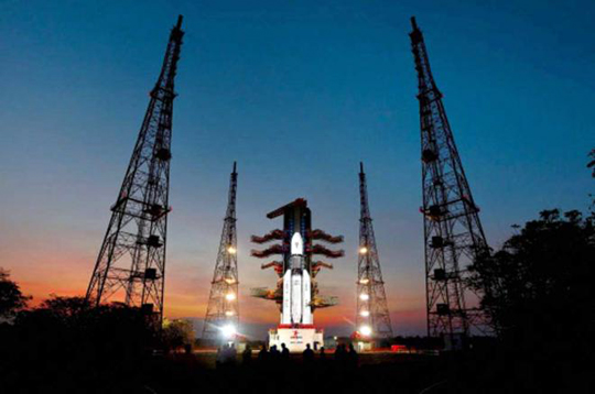
Chennai, Jun 5: Taking a big leap forward in the space technology, the Indian Space Research Organisation (ISRO) successfully launched its heaviest rocket GSLV-Mk-III carrying communication satellite at country's spaceport in Sriharikota near here.
sat

GSLV-Mk-III, the first of its kind mission, is capable launching four ton class of satellites to Geosynchronous Transfer Orbit (GTO). The GSLV rocket is the first developmental flight, carrying 3,136 kg GSAT-19 satellite to a GTO.

The GSLV rocket took off from the second launch pad at SDSC SHAR in Sriharikota about 90 kilometres from north Chennai at 5.28 pm. After about 16 minutes into its flight, the rocket successfully placed GSAT-19 in its intended orbit.

Soon after the GSLV-Mk-III mission success Indian Space Research Organisation (ISRO) Chairman A.S.Kiran Kumar said it was a historic day.

Stating that the heavy rocket was designed in 2002, Kiran Kumar said that after a gap of 15 years, the ISRO team were able to achieve the successful launch of GSLV-Mk-III.

He congratulated the entire ISRO team which worked hard on the GSLV mission.

ISRO sources said that the design and development of GSLV Mk III is based on ISRO's rich experience in handling solid, liquid and cryogenic rocket propulsion technologies. The first suborbital test flight of GSLV Mk- III was successfully conducted on December 18, 2014.

GSAT-19 satellite with a lift-off mass of 3136 kg, is the communication satellite of India, configured around the ISRO"s standard I-3K bus.

GSAT-19 carries Ka/Ku-band high throughput communication transponders. Besides, it carries a Geostationary Radiation Spectrometer (GRASP) payload to monitor and study the nature of charged particles and the influence of space radiation on satellites and their electronic components.

GSAT-19 also features certain advanced spacecraft technologies including miniaturised heat pipe, fibre optic gyro, Micro Electro-Mechanical Systems (MEMS) accelerometer, Ku-band TTC transponder, as well an indigenous Lithium-ion Battery.

Comments

Add new comment

  • Coastaldigest.com reserves the right to delete or block any comments.
  • Coastaldigset.com is not responsible for its readers’ comments.
  • Comments that are abusive, incendiary or irrelevant are strictly prohibited.
  • Please use a genuine email ID and provide your name to avoid reject.
Agencies
February 5,2020

San Francisco, Feb 5: After a German artist, Simon Weckert, demonstrated how he "hacked" Google Maps with 99 smartphones and a wagon to create "virtual traffic jams" on the streets of Berlin, Google responded to the incident saying it "appreciates" creative use of maps.

Admitting that it has not quite cracked travelling by wagon, the tech giant also hinted that it might use cases like this to improve how its maps work.

"We appreciate seeing creative uses of Google Maps like this as it helps us make maps work better over time," 9to5Google quoted a Google spokesperson as saying.

In a YouTube video, Weckert showed that he put 99 smartphones with Google Maps onto a small wagon cart and then wheeled that cart around various streets in Berlin, including outside the Google office, Android Authority reported on Monday.

The smartphones "apparently fooled Google Maps" into thinking that there was a high concentration of users on those streets.

Because the second-hand phones were in a cart, Maps was further tricked into believing that the traffic was slow-moving.

As a result, the navigation app started showing virtual traffic jams by turning green streets to red in the online navigational tool, showcasing how digital technology can have a real impact on the real world.

"Traffic data in Google Maps is refreshed continuously thanks to information from a variety of sources, including aggregated anonymised data from people who have location services turned on and contributions from the Google Maps community," the Google spokesperson said.

"We've launched the ability to distinguish between cars and motorcycles in several countries including India, Indonesia and Egypt, though we haven't quite cracked travelling by wagon," the statement added. After a German artist, Simon Weckert, demonstrated how he "hacked" Google Maps with 99 smartphones and a wagon to create "virtual traffic jams" on the streets of Berlin, Google responded to the incident saying it "appreciates" creative use of maps.

Admitting that it has not quite cracked travelling by wagon, the tech giant also hinted that it might use cases like this to improve how its maps work.

"We appreciate seeing creative uses of Google Maps like this as it helps us make maps work better over time," 9to5Google quoted a Google spokesperson as saying.

In a YouTube video, Weckert showed that he put 99 smartphones with Google Maps onto a small wagon cart and then wheeled that cart around various streets in Berlin, including outside the Google office, Android Authority reported on Monday.

The smartphones "apparently fooled Google Maps" into thinking that there was a high concentration of users on those streets.

Because the second-hand phones were in a cart, Maps was further tricked into believing that the traffic was slow-moving.

As a result, the navigation app started showing virtual traffic jams by turning green streets to red in the online navigational tool, showcasing how digital technology can have a real impact on the real world.

"Traffic data in Google Maps is refreshed continuously thanks to information from a variety of sources, including aggregated anonymised data from people who have location services turned on and contributions from the Google Maps community," the Google spokesperson said.

"We've launched the ability to distinguish between cars and motorcycles in several countries including India, Indonesia and Egypt, though we haven't quite cracked travelling by wagon," the statement added.

Comments

Add new comment

  • Coastaldigest.com reserves the right to delete or block any comments.
  • Coastaldigset.com is not responsible for its readers’ comments.
  • Comments that are abusive, incendiary or irrelevant are strictly prohibited.
  • Please use a genuine email ID and provide your name to avoid reject.
Agencies
June 19,2020

Denser places, assumed by many to be more conducive to the spread of the coronavirus that causes COVID-19, are not linked to higher infection rates, say researchers.

The study, led by Johns Hopkins University, published in the Journal of the American Planning Association, also found that dense areas were associated with lower COVID-19 death rates.

"These findings suggest that urban planners should continue to practice and advocate for compact places rather than sprawling ones, due to the myriad well-established benefits of the former, including health benefits," says study lead author Shima Hamidi from Johns Hopkins Bloomberg School of Public Health in the US.

For their analysis, the researchers examined SARS-CoV-2 infection rates and COVID-19 death rates in 913 metropolitan counties in the US.

When other factors such as race and education were taken into account, the authors found that county density was not significantly associated with county infection rate.

The findings also showed that denser counties, as compared to more sprawling ones, tended to have lower death rates--possibly because they enjoyed a higher level of development including better health care systems.

On the other hand, the research found that higher coronavirus infection and COVID-19 mortality rates in counties are more related to the larger context of metropolitan size in which counties are located.

Large metropolitan areas with a higher number of counties tightly linked together through economic, social, and commuting relationships are the most vulnerable to the pandemic outbreaks.

According to the researchers, recent polls suggest that many US citizens now consider an exodus from big cities likely, possibly due to the belief that more density equals more infection risk.

Some government officials have posited that urban density is linked to the transmissibility of the virus.

"The fact that density is unrelated to confirmed virus infection rates and inversely related to confirmed COVID-19 death rates is important, unexpected, and profound," said Hamidi.

"It counters a narrative that, absent data and analysis, would challenge the foundation of modern cities and could lead to a population shift from urban centres to suburban and exurban areas," Hamidi added.

The analysis found that after controlling for factors such as metropolitan size, education, race, and age, doubling the activity density was associated with an 11.3 per cent lower death rate.

The authors said that this is possibly due to faster and more widespread adoption of social distancing practices and better quality of health care in areas of denser population.

The researchers concluded that a higher county population, a higher proportion of people age 60 and up, a lower proportion of college-educated people, and a higher proportion of African Americans were all associated with a greater infection rate and mortality rate.

Comments

Add new comment

  • Coastaldigest.com reserves the right to delete or block any comments.
  • Coastaldigset.com is not responsible for its readers’ comments.
  • Comments that are abusive, incendiary or irrelevant are strictly prohibited.
  • Please use a genuine email ID and provide your name to avoid reject.
News Network
January 17,2020

Bengaluru, Jan 17: India’s latest communication satellite GSAT-30 was successfully launched from the Spaceport in French Guiana during the early hours on Friday.

In a press release, ISRO, has stated that the launch vehicle 'Ariane-5 VA-251' was blasted off from Kourou Launch Base, French Ginana at 0230 hours, carrying India’s GSA-30 and EUTELSAT KONNECT for Eutelasat, as per schedule.

The Ariane 5 upper stage in an elliptical Geosynchronous Transfer Orbit.

With a lift-off mass of 3,357 kg, GSAT-30 will provide continuity to operational services on some of the in-orbit satellites.

GSAT-30 derives its heritage from ISRO’s earlier INSAT/GSAT satellite series and will replace INSAT-4A in orbit.

“GSAT-30 has a unique configuration of providing flexible frequency segments and flexible coverage. The satellite will provide communication services to Indian mainland and islands through Ku-band and wide coverage covering Gulf countries, a large number of Asian countries and Australia through C-band," ISRO Chairman Dr K Sivan said.

Dr Sivan also said that “GSAT-30 will provide DTH Television Services, connectivity to VSATs for ATM, Stock-exchange, Television uplinking and teleport Services, Digital Satellite News Gathering (DSNG) and e-governance applications. The satellite will also be used for bulk data transfer for a host of emerging telecommunication applications.”

ISRO’s Master Control Facility (MCF) at Hassan in Karnataka took over the command and control of GSAT-30 immediately after its separation from the launch vehicle. Preliminary health checks of the satellite revealed its normal health.

In the days ahead, orbit-raising maneuvers will be performed to place the satellite in Geostationary Orbit (36,000 km above the equator) by using its onboard propulsion system.

During the final stages of its orbit raising operations, the two solar arrays and the antenna reflectors of GSAT-30 will be deployed. Following this, the satellite will be put in its final orbital configuration.

The satellite will be operational after the successful completion of all in-orbit tests.

Comments

Add new comment

  • Coastaldigest.com reserves the right to delete or block any comments.
  • Coastaldigset.com is not responsible for its readers’ comments.
  • Comments that are abusive, incendiary or irrelevant are strictly prohibited.
  • Please use a genuine email ID and provide your name to avoid reject.