Cyclone Nilam aftermath: 22 dead in AP, more rain likely in 24 hours

November 5, 2012

nilam_5

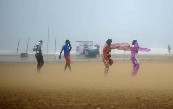
Hyderabad, November 5: Twenty-two people have died in coastal Andhra Pradesh as heavy rains continued to lash the region in the after effect of the Cyclone Nilam. Coastal Andhra Pradesh has been witnessing heavy rainfall over the past 48 hours.

Vishakapatnam, Prakasam, East Godavari and Viziana-garam have received close to 25 cm of rainfall since Saturday. People from low lying areas have been evacuated to relief camps. More rainfall is expected in next 24 hours.

District officials are on alert. "We forecast more rains in the next 48 hours and if the forecast is true more losses and casualties can be expected," T Radha, Commissioner, Disaster Management, said.

The rainfall on Sunday was such that Narasapur in West Godavari district received a record 31 cms of rainfall in the last 24 hours, followed by 27 cms in Amalapuram, 25 cms in Rajahmundry (both in East Godavari district), 25 cms in Yelamanchili (Visakhapatnam dist), 23 cms in Koderu (West Godavari district).

Standing crops, including paddy, were affected in 2,43,634 hectares. The government has set up 86 relief camps in which about 68,000 people were provided shelter, he said.

Andhra Pradesh Chief Minister N Kiran Kumar Reddy directed chief secretary Minnie Mathew to put all concerned departments on high alert and closely monitor the flood and heavy rains situation. He reviewed the situation with the chief secretary and other senior officials from New Delhi over phone and asked them to make all efforts for relief and rescue measures. He also spoke to collectors of rain-hit districts, a release from the chief minister's office said.


Comments

Add new comment

  • Coastaldigest.com reserves the right to delete or block any comments.
  • Coastaldigset.com is not responsible for its readers’ comments.
  • Comments that are abusive, incendiary or irrelevant are strictly prohibited.
  • Please use a genuine email ID and provide your name to avoid reject.
News Network
May 20,2020

May 20: Prime Minister K P Sharma Oli on Tuesday asserted that Lipulekh, Kalapani and Limpiyadhura belong to Nepal and vowed to "reclaim" them from India through political and diplomatic efforts, as his Cabinet endorsed a new political map showing the three areas as Nepalese territory.

Addressing Parliament, Oli said the territories belong to Nepal “but India has made it a disputed area by keeping its Army there”. “Nepalis were blocked from going there after India stationed its Army,” he said.

“India has deployed its troops in Kalapani since 1962 and our rulers in the past hesitated to raise the issue,” he said, asserting, “We will reclaim and get them back.”

The prime minister asserted that the Nepal government will make political and diplomatic efforts to reclaim the territory.

Oli also expressed the hope that India will “follow the path of truth, shown by Satya Meva Jayate, which is mentioned in the Ashoka Chakra, the national symbol of India”.

The prime minister’s remarks came a day after the Cabinet headed by him endorsed a new political map showing Lipulekh, Kalapani and Limpiyadhura under Nepal’s territory.

Foreign Minister Pradeep Kumar Gyawali said the official map of Nepal will soon be made public by the Ministry of Land Management. The move announced by Gyawali came weeks after he said that efforts were on to resolve the border issue with India through diplomatic initiatives.

Nepal''s ruling Nepal Communist Party lawmakers have also tabled a special resolution in Parliament demanding return of Kalapani, Limpiyadhura and Lipulekh to Nepal.

The Lipulekh pass is a far western point near Kalapani, a disputed border area between Nepal and India. Both India and Nepal claim Kalapani as an integral part of their territory - India as part of Uttarakhand’s Pithoragarh district and Nepal as part of Dharchula district.

Gyawali last week summoned the Indian Ambassador Vinay Mohan Kwatra and handed over a diplomatic note to him to protest against the construction of a key road connecting the Lipulekh pass with Dharchula in Uttarakhand.

India has said that the recently-inaugurated road section in Pithoragarh district in Uttarakhand lies completely within its territory. Indian Army chief Gen MM Naravane last week said that there were reasons to believe that Nepal objected to India''s newly-inaugurated road linking Lipulekh Pass with Dharchula in Uttarakhand at the behest of "someone else", in an apparent reference to a possible role by China on the matter.

He said there was no dispute whatsoever between India and Nepal in the area and road laid was very much within the Indian side.

The 80-KM-long strategically crucial road at a height of 17,000 KM along the border with China in Uttarakhand was thrown open by Defence Minister Rajnath Singh earlier this month.

Nepal has raised objection to the inauguration of the road, saying the "unilateral act" was against the understanding reached between the two countries on resolving the border issues. China on Tuesday said the Kalapani border issue is between India and Nepal as it hoped that the two neighbours could refrain from "unilateral actions" and properly resolve their disputes through friendly consultations.

After the endorsement of Nepal’s new map senior ruling party leader and member of Nepal Communist Party Standing Committee Ganesh Shah said the new move may escalate unnecessary tension between Nepal and India at a time when the country is fighting the coronavirus.

"The Nepal government should soon start a dialogue with India to resolve the matter through political and diplomatic moves," he said.

The new map includes 335-km land area including Limpiyadhura in the Nepalese territory.

The new map was drawn on the basis of the Sugauli Treaty of 1816 signed between Nepal and then the British India government and other relevant documents, which suggests Limpiyadhura, from where the Kali river originated, is Nepal''s border with India, The Kathmandu Post quoted an official at the Ministry of Land Reform and Management as saying.

India and Nepal are at a row after the Indian side issued a new political map incorporating Kalapani and Lipulekh on its side of the border in October last year.

The tension further escalated after India inaugurated the road link connecting Kailash Mansarovar, a holy pilgrimage site situated at Tibet, China, that passes through the territory belonging to Nepal.
Comments

Add new comment

  • Coastaldigest.com reserves the right to delete or block any comments.
  • Coastaldigset.com is not responsible for its readers’ comments.
  • Comments that are abusive, incendiary or irrelevant are strictly prohibited.
  • Please use a genuine email ID and provide your name to avoid reject.
News Network
May 20,2020

Kolkata, May 20: Cyclone 'Amphan' lay centred about 240 km south of Digha in West Bengal on Wednesday morning as an extremely severe cyclonic storm, the Met department said here.

The intensity near the centre of the storm was 170 to 180 kmph gusting to 200 kmph, the Met said.

'Amphan' is very likely to move north-northeastwards and cross West Bengal-Bangladesh coast between Digha and Hatiya, close to the Sunderbans during the afternoon to evening of Wednesday with a wind speed of 155 to 165 kmph gusting to 185 kmph as a 'very severe cyclonic storm', the Met department said.

West Bengal has evacuated more than three lakh people to safer places as the cyclonic storm 'Amphan' roared towards the coastal areas of the state, officials said.

The Met department, which has issued an "orange message" for West Bengal, warned of extensive damage in Kolkata, Hooghly, Howrah, South and North 24 Parganas and East Midnapore districts.

The Met department has advised that all establishments and markets remain closed in Kolkata and adjoining areas and movement of people be restricted on May 20.

There is likely to be disruption of rail and road link at several places, uprooting of communication and power poles, extensive damage to all types of 'kutcha' houses and some damage to "old badly managed pucca" structures and potential threat from flying objects, the weatherman warned.

There is also likelihood of extensive damage to standing crops, plantations and orchards and blowing down of palm and coconut trees, the Met said.

The weatherman has advised diversion or suspension of rail and road traffic in the districts which are likely to be affected.

The Eastern Railway (ER) has cancelled the departure of Howrah-New Delhi AC Special Express for Wednesday.

The departure of 02301 Howrah-New Delhi AC Special Express on Wednesday and 02302 New Delhi-Howrah AC Special Express on May 21 would remain cancelled, the ER said.

Wind speed along and off the coastal areas of West Bengal will reach 75 to 85 kmph with gusts up to 95 kmph from Wednesday morning along and off districts of North and South 24 Parganas, East and West Midnapore, Kolkata, Howrah and Hooghly, Regional Met director G K Das said.

"It will gradually increase thereafter becoming 110 to 120 kmph gusting to 130 kmph over West Midnapore, Howrah, Hooghly, Kolkata and wind speed of 155 to 165 kmph gusting to 185 kmph over the districts of North and South 24 Parganas and East Midnapore of West Bengal from the afternoon to night of May 20," he said.

Under its impact rainfall will occur in most places over the districts of Gangetic West Bengal on Wednesday, with heavy to very heavy downpour with extremely heavy rain at a few places in Kolkata, Howrah, East Midnapore, North and South 24 Parganas and Hooghly districts, he said.

"Storm surge of 4 to 5 metres above astronomical tide is likely to inundate low lying areas of South and North 24 Parganas and about 3 to 4 metres over low lying areas of East Midnapore district of West Bengal during the time of landfall," he said.

The Indian Navy has dispatched a diving team for providing assistance to the West Bengal government in relief operations, a Defence official said.

The diving team from Vishakhapatnam has brought specialised equipment along with them which can be used for rescue in case of flooding and have been positioned at the Naval Service Selection Board at Diamond Harbour in South 24 Parganas district, the official said.

Comments

Add new comment

  • Coastaldigest.com reserves the right to delete or block any comments.
  • Coastaldigset.com is not responsible for its readers’ comments.
  • Comments that are abusive, incendiary or irrelevant are strictly prohibited.
  • Please use a genuine email ID and provide your name to avoid reject.
Agencies
February 5,2020

New Delhi, Feb 5: AIMIM chief Asaduddin Owaisi on Wednesday expressed his suspicion over the government using force to clear the Shaheen Bagh stretch where an agitation has been ongoing for over 50 days against Citizenship Amendment Act (CAA).

While speaking to ANI over the phone, Owaisi was asked that there are indications from the government that after February 8, Shaheen Bagh will be cleared.

In reply, he said, "Might be they will shoot them, they might turn Shaheen Bagh into Jallianwala Bagh. This might happen. BJP minister gave a statement to 'shoot a bullet'. The government must give an answer as (to) who is radicalising."

Further speaking about NPR and NRC, Owaisi said, "Government must give a clear cut answer that till 2024 NRC will not be implemented. Why are they spending Rs 3900 crore for NPR? I feel this way because I was a History student. Hitler during his reign conducted census twice and after that, he pushed the jews in a gas chamber. I don't want our country (to) go in that way."

Comments

Add new comment

  • Coastaldigest.com reserves the right to delete or block any comments.
  • Coastaldigset.com is not responsible for its readers’ comments.
  • Comments that are abusive, incendiary or irrelevant are strictly prohibited.
  • Please use a genuine email ID and provide your name to avoid reject.