Unmanned US Air Force space plane lands after secret, 2-year mission

May 8, 2017

Cape Canaveral, May 8: The US military"s experimental X-37B space plane landed on Sunday at NASA"s Kennedy Space Center in Florida, completing a classified mission that lasted nearly two years, the Air Force said.

AirForce

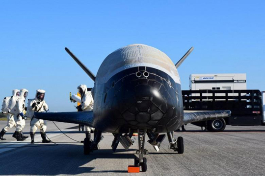
The unmanned X-37B, which resembles a miniature space shuttle, touched down at 7:47 a.m. EDT (1147 GMT) on a runway formerly used for landings of the now-mothballed space shuttles, the Air Force said in an email. The Boeing-built space plane blasted off in May 2015 from nearby Cape Canaveral Air Force Station aboard an Atlas 5 rocket built by United Launch Alliance, a partnership between Lockheed Martin Corp and Boeing Co.

The X-37B, one of two in the Air Force fleet, conducted unspecified experiments for more than 700 days while in orbit. It was the fourth and lengthiest mission so far for the secretive program, managed by the Air Force Rapid Capabilities Office. The orbiters “perform risk reduction, experimentation and concept-of-operations development for reusable space vehicle technologies,” the Air Force has said without providing details. The cost of the program is also classified.

The Secure World Foundation, a nonprofit group promoting the peaceful exploration of space, says the secrecy surrounding the X-37B suggests the presence of intelligence-related hardware being tested or evaluated aboard the craft. The vehicles are 29 feet (9 meters) long and have a wingspan of 15 feet, making them about one quarter of the size of the National Aeronautics and Space Administration"s now-retired space shuttles.

The X-37B, also known as Orbital Test Vehicle, or OTV, first flew in April 2010 and returned after eight months. A second mission launched in March 2011 and lasted 15 months, while a third took flight in December 2012 and returned after 22 months.

Sunday"s landing was the X-37B"s first in Florida. The three previous landings took place at Vandenberg Air Force Base in California. The Air Force relocated the program in 2014, taking over two of NASA"s former shuttle-processing hangars.

The Air Force intends to launch the fifth X-37B mission from Cape Canaveral Air Force Station, located just south of the Kennedy Space Center, later this year.

Comments

Add new comment

  • Coastaldigest.com reserves the right to delete or block any comments.
  • Coastaldigset.com is not responsible for its readers’ comments.
  • Comments that are abusive, incendiary or irrelevant are strictly prohibited.
  • Please use a genuine email ID and provide your name to avoid reject.
Agencies
May 15,2020

Kolkata, May 15: Veteran Bengali author Debesh Roy, who was conferred the Sahitya Akademi award for his novel 'Teesta Parer Brittanto', died at a private hospital in Kolkata on Thursday, his family members said.

Roy was 84 and he is survived by his son. His wife had died earlier.

He was admitted to the hospital near his residence at Baguihati, in the eastern fringes of the city, on Wednesday after having symptoms like sodium potasium imbalance, sugar problem and breathing problem, his family members said.

He suffered a massive cardiac arrest and died at 10.50 PM.

A regular contributor to a number of Bengali dailies, he was a staunch critic of the attacks on liberals by in the country in recent times and attended protest meetings despite his failing health.

He was born in Pabna in present-day Bangladesh on December 17, 1936. He had five decades of career as a writer.

Besides Teesta Parer Britanta', he will be remembered for books like Borisaler Jogen Mondal , Manush Khun Kore Keno and Samay Asamayer Brittanto . His first book was Jajati.

His last rites will be performed tomorrow.

Comments

Add new comment

  • Coastaldigest.com reserves the right to delete or block any comments.
  • Coastaldigset.com is not responsible for its readers’ comments.
  • Comments that are abusive, incendiary or irrelevant are strictly prohibited.
  • Please use a genuine email ID and provide your name to avoid reject.
Agencies
July 4,2020

The Mars Colour Camera (MCC) onboard ISRO's Mars Orbiter Mission has captured the image of Phobos, the closest and biggest moon of Mars.

The image was taken on July 1 when MOM was about 7,200 km from Mars and 4,200 km from Phobos.

"Spatial resolution of the image is 210 m.

This is a composite image generated from 6 MCC frames and has been color corrected," ISRO said in an update along with the image.

Phobos is largely believed to be made up of carbonaceous chondrites.

According to ISRO, "the violent phase that Phobos has encountered is seen in the large section gouged out from a past collision (Stickney crater) and bouncing ejecta."

"Stickney, the largest crater on Phobos along with the other craters (Shklovsky, Roche & Grildrig) are also seen in this image," it said.

The mission also known as Mangalyaan was initially meant to last six months, but subsequently ISRO had said it had enough fuel for it to last "many years."

The country had on September 24, 2014 successfully placed the Mars Orbiter Mission spacecraft in orbit around the red planet, in its very first attempt, thus breaking into an elite club.

ISRO had launched the spacecraft on its nine-month- long odyssey on a homegrown PSLV rocket from Sriharikota in Andhra Pradesh on November 5, 2013.

It had escaped the earth's gravitational field on December 1, 2013.

The Rs 450-crore MOM mission aims at studying the Martian surface and mineral composition as well as scan its atmosphere for methane (an indicator of life on Mars).

The Mars Orbiter has five scientific instruments - Lyman Alpha Photometer (LAP), Methane Sensor for Mars (MSM), Mars Exospheric Neutral Composition Analyser (MENCA), Mars Colour Camera (MCC) and Thermal Infrared Imaging Spectrometer

Comments

Add new comment

  • Coastaldigest.com reserves the right to delete or block any comments.
  • Coastaldigset.com is not responsible for its readers’ comments.
  • Comments that are abusive, incendiary or irrelevant are strictly prohibited.
  • Please use a genuine email ID and provide your name to avoid reject.
Agencies
February 5,2020

San Francisco, Feb 5: After a German artist, Simon Weckert, demonstrated how he "hacked" Google Maps with 99 smartphones and a wagon to create "virtual traffic jams" on the streets of Berlin, Google responded to the incident saying it "appreciates" creative use of maps.

Admitting that it has not quite cracked travelling by wagon, the tech giant also hinted that it might use cases like this to improve how its maps work.

"We appreciate seeing creative uses of Google Maps like this as it helps us make maps work better over time," 9to5Google quoted a Google spokesperson as saying.

In a YouTube video, Weckert showed that he put 99 smartphones with Google Maps onto a small wagon cart and then wheeled that cart around various streets in Berlin, including outside the Google office, Android Authority reported on Monday.

The smartphones "apparently fooled Google Maps" into thinking that there was a high concentration of users on those streets.

Because the second-hand phones were in a cart, Maps was further tricked into believing that the traffic was slow-moving.

As a result, the navigation app started showing virtual traffic jams by turning green streets to red in the online navigational tool, showcasing how digital technology can have a real impact on the real world.

"Traffic data in Google Maps is refreshed continuously thanks to information from a variety of sources, including aggregated anonymised data from people who have location services turned on and contributions from the Google Maps community," the Google spokesperson said.

"We've launched the ability to distinguish between cars and motorcycles in several countries including India, Indonesia and Egypt, though we haven't quite cracked travelling by wagon," the statement added. After a German artist, Simon Weckert, demonstrated how he "hacked" Google Maps with 99 smartphones and a wagon to create "virtual traffic jams" on the streets of Berlin, Google responded to the incident saying it "appreciates" creative use of maps.

Admitting that it has not quite cracked travelling by wagon, the tech giant also hinted that it might use cases like this to improve how its maps work.

"We appreciate seeing creative uses of Google Maps like this as it helps us make maps work better over time," 9to5Google quoted a Google spokesperson as saying.

In a YouTube video, Weckert showed that he put 99 smartphones with Google Maps onto a small wagon cart and then wheeled that cart around various streets in Berlin, including outside the Google office, Android Authority reported on Monday.

The smartphones "apparently fooled Google Maps" into thinking that there was a high concentration of users on those streets.

Because the second-hand phones were in a cart, Maps was further tricked into believing that the traffic was slow-moving.

As a result, the navigation app started showing virtual traffic jams by turning green streets to red in the online navigational tool, showcasing how digital technology can have a real impact on the real world.

"Traffic data in Google Maps is refreshed continuously thanks to information from a variety of sources, including aggregated anonymised data from people who have location services turned on and contributions from the Google Maps community," the Google spokesperson said.

"We've launched the ability to distinguish between cars and motorcycles in several countries including India, Indonesia and Egypt, though we haven't quite cracked travelling by wagon," the statement added.

Comments

Add new comment

  • Coastaldigest.com reserves the right to delete or block any comments.
  • Coastaldigset.com is not responsible for its readers’ comments.
  • Comments that are abusive, incendiary or irrelevant are strictly prohibited.
  • Please use a genuine email ID and provide your name to avoid reject.